The History of Wick's Harbour: A Local Explainer
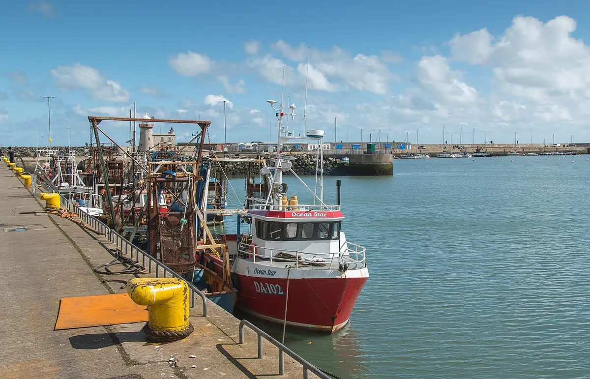
Stand on the quay at Wick and look out past the breakwater, and it is hard to picture the scene 150 years ago: boats packed so tightly in the basin you could almost walk across their decks, and hundreds of women gutting herring on the shore from first light until dark. The harbour is the reason Wick looks the way it does. The grid of streets in Pulteneytown, the curing yards, the rows of workers' cottages — all of it grew up around the water. Here is how that came about, and where the port stands now.
A harbour built for herring
Wick sits at the mouth of the Wick Water on the far north-east coast of Caithness, and boats have used that sheltered bay for centuries. What turned a natural landing place into a proper port was the British Fisheries Society, founded in 1786 to develop fishing along Scotland's northern and western coasts.
The society chose Wick, and from 1803 it began building Pulteneytown on the south side of the river — a planned settlement rather than a place that grew by accident. The harbour works were overseen by the engineer Thomas Telford, whose designs shaped the basin and the early breakwater. That is why the layout still feels deliberate today: broad quays, straight streets set behind them, and a clear separation between the working waterfront and the houses.
Herring town
The fish did the rest. Through the nineteenth century Wick became the largest herring port in Europe. Drifters came from right along the Scottish coast and beyond, and during the peak season the curing yards turned the catch into salted barrels bound for markets in the Baltic, Germany and Russia.
Most of the work was done by women. The gutters — the herring lassies, as they were known along the coast — followed the fleet as it moved round Britain, from Shetland down through Wick and Fraserburgh and on to Yarmouth by the autumn. They stood at the barrels for long shifts, hands bound against the cuts, and were paid by the barrel rather than by the hour. It is easy to skim past them in the history books, but the trade could not have worked without them: a herring has to be gutted and packed within hours of landing, or it is fit for nothing.
The shape of the harbour
What you see today was built up in stages, as the trade demanded more room and the weather demanded more shelter.
- The inner harbour, closest to the town, handled smaller boats and much of the curing work.
- The outer harbour and breakwater gave protection from the north-east swell that makes this coast so unforgiving.
- Piers and quays were added, rebuilt and extended through the nineteenth and twentieth centuries as one fishery rose and another fell.
A harbour is never finished. Storm damage, silting and shifting fishing patterns have meant almost continuous repair work for two centuries, paid for at different times by the fisheries society, the town and public bodies.
Decline
The boom did not last. Tastes changed, markets shifted, and the First World War disrupted the trade. Herring fell out of fashion as cheap food during the twentieth century, and the industry contracted along the whole British coast. By the middle of the 1900s, a harbour that had once needed crowd control on the quays was very much quieter.
The town's population fell with the trade, and the grander buildings of Pulteneytown were left behind as reminders of a wealthier era. That is part of what gives the area its odd, slightly formal character today.
The harbour today
Wick is still a working port, but the work has changed. Commercial fishing continues, with boats landing shellfish and other catch. The harbour is also a base for vessels supporting offshore energy, including the operations base for the Beatrice offshore wind farm, whose technicians head out from Wick to the turbines in the Moray Firth. Cruise ships call in, with passengers brought ashore to look round the town, and the marina and pontoons are used by visiting yachts making their way round the north coast.
If you want to make sense of the whole story, the Wick Heritage Museum is the place to start. Its photographic archive of the herring years is the best record there is of the faces behind the barrels.
Looking ahead
Wick's harbour has survived by repeatedly changing what it does for a living. Offshore wind, decommissioning work, cruise visits and leisure moorings now sit alongside the fishing that still ties the port to its past, and Wick Harbour Authority manages the day-to-day running of the site.
For anyone with an interest in the town's future, this is the place to watch. Decisions about Wick's economy tend to show up at the harbour first — in a new berth, a new contract, or a ship that was not calling here a decade ago.
Visiting the harbour
An hour on foot is enough to get a feel for the place, and it costs nothing. A few practical notes:
- Start at the Heritage Museum in Pulteneytown, then walk down towards the river. You will understand more of what you are looking at.
- Cross the bridge and look back — that is the best view of the basin and the streets behind it.
- Follow the quayside and watch the working boats. The smell of creosote and diesel is a reminder that this is a real port, not a museum piece.
- Carry on towards the breakwater for the view back over the town and out to sea.
- Check the tide and the forecast before you set off. The wind off the North Sea is no joke, and the outer pier can be slippery when wet.
Opening times at the museum and at any cafés or shops round the harbour vary with the season, so check ahead if you are making a special trip. Wear something windproof whatever the forecast says. And take a moment on the quay to picture those packed decks and the gutting crews — this small basin really was once the busiest herring port in Europe.
Photo: wagrati_photo / Pixabay

You Might Also Like
A practical checklist to help Wick residents get through the Caithness winter, from lagging pipes and gritting paths to emergency kits and checking on neighbours.
Wick's teenagers have nowhere to go and little to do. A properly funded youth centre would be cheaper than the alternative — and the town already has the money, the buildings and the people.